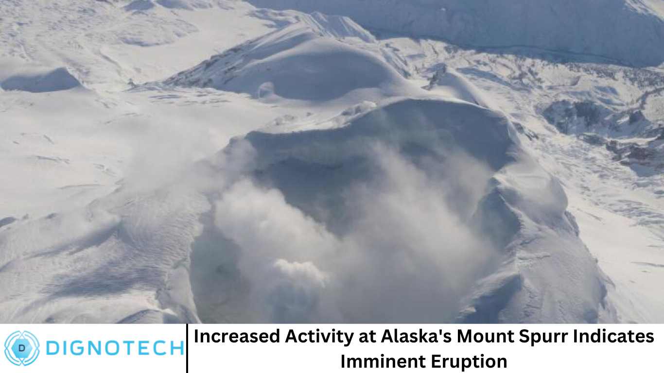
Hi everyone! How are you all doing? Welcome to dignotech.com! Alaska’s Mount Spurr, an active stratovolcano located about 80 miles west of Anchorage, has recently exhibited significant volcanic activity, raising concerns about a possible imminent eruption. Known for its explosive eruptions and volcanic history, the mountain has been under close monitoring by scientists from the United States Geological Survey (USGS) and other agencies, as changes in its activity could impact local communities, air traffic, and the environment.
This article provides a comprehensive overview of Mount Spurr’s volcanic activity, its potential for eruption, and what scientists are observing. Additionally, we will delve into the history of volcanic activity in Alaska, the technologies used to monitor volcanoes, and the potential hazards an eruption could pose.
What Is Mount Spurr?
Mount Spurr is part of the Aleutian volcanic arc, which is a region of active volcanoes stretching from Alaska to the Kamchatka Peninsula in Russia. This arc lies along the boundary between the Pacific and North American tectonic plates, a region known for frequent seismic and volcanic activity. Mount Spurr, in particular, is considered an active volcano that has erupted several times in the past, with its most recent eruption occurring in 1992.
Standing at 11,070 feet (3,373 meters), Mount Spurr is a prominent peak in Alaska’s volcanic landscape. The volcano is characterized by a conical shape, which is typical of stratovolcanoes. Stratovolcanoes, or composite volcanoes, are large, steep-sided mountains formed by the buildup of lava flows, ash, and other volcanic debris. They are known for producing explosive eruptions, often accompanied by pyroclastic flows and ash clouds that can reach high altitudes.
Recent Activity at Mount Spurr
In recent months, Mount Spurr has shown signs of increased volcanic activity, prompting scientists to ramp up their monitoring efforts. The signs include elevated seismic activity, ground deformation, and increased gas emissions, all of which are indicators that magma may be rising beneath the surface.
Seismic activity is one of the most significant indicators of volcanic unrest. A series of small earthquakes, known as volcano-tectonic earthquakes, have been recorded near the volcano, suggesting that the movement of magma beneath the surface is causing stress on the surrounding rocks. While these quakes are typically too small to be felt by people, they are a key signal to scientists that the volcano is becoming more active.
Ground deformation, or the shifting of the earth’s surface, is another critical sign of volcanic unrest. Monitoring stations equipped with satellite-based systems like InSAR (Interferometric Synthetic Aperture Radar) and GPS are used to measure even minute changes in the shape of the volcano’s surface. A noticeable increase in deformation around Mount Spurr indicates that magma is likely moving within the volcano, potentially pressurizing the magma chamber and increasing the risk of an eruption.
In addition to seismic and ground activity, gas emissions from the volcano have also increased. Volcanoes release gases such as sulfur dioxide (SO2), carbon dioxide (CO2), and water vapor when magma rises to the surface. An increase in gas emissions can signal that magma is nearing the surface and may be preparing for an eruption. Scientists use remote sensing technology to measure these emissions, and the higher the concentration of gases, the greater the likelihood of an impending eruption.
The Potential for an Imminent Eruption
While the increased activity at Mount Spurr is concerning, scientists cannot predict exactly when or how the volcano will erupt. Volcanic eruptions are notoriously difficult to forecast with precision, and much depends on the underlying dynamics of the volcano. However, based on the current signs, experts are closely monitoring the situation and preparing for the possibility of an eruption in the near future.
If Mount Spurr does erupt, it could produce a range of volcanic hazards. One of the primary concerns is the potential for ash clouds that could disrupt air travel. The 1992 eruption of Mount Spurr sent a massive ash cloud into the atmosphere, which impacted air traffic across Alaska and beyond. Ash clouds can pose significant risks to aviation by damaging aircraft engines, reducing visibility, and forcing flight cancellations or diversions.
Another potential hazard is pyroclastic flows, which are fast-moving currents of hot gas, ash, and volcanic debris. These flows can travel at speeds of up to 100 miles per hour and can be deadly to anyone in their path. While Mount Spurr’s previous eruptions have not produced large pyroclastic flows, the risk remains if the volcano becomes more explosive.
Lahars, or volcanic mudflows, are also a concern. These flows occur when volcanic ash mixes with water from rain or melting snow, creating a fast-moving slurry of mud and debris. Lahars can travel far from the volcano, damaging infrastructure and posing a risk to human life.
Historical Eruptions of Mount Spurr
Mount Spurr has a history of explosive eruptions, and scientists are keeping this in mind as they assess current activity. Its most recent eruption in 1992 lasted for several months and was characterized by an initial explosive phase followed by continuous lava dome growth. The eruption produced significant ash fallout that affected air traffic and nearby communities. Although no fatalities were reported, the eruption demonstrated the potential risks associated with Mount Spurr’s volcanic activity.
The 1992 eruption was preceded by increased seismic activity and gas emissions, similar to what is being observed today. This historical context suggests that the volcano is capable of producing eruptions of varying magnitudes, ranging from explosive events to more localized lava flows.
Monitoring and Preparedness Efforts
To better understand Mount Spurr’s current activity and forecast any potential eruptions, scientists are utilizing a range of monitoring techniques. The Alaska Volcano Observatory (AVO), in collaboration with the USGS and other agencies, uses a combination of seismic networks, ground deformation measurements, satellite imagery, and gas monitoring systems to track volcanic activity.
Seismic stations located around Mount Spurr record earthquake activity in real-time, allowing scientists to assess the level of seismic unrest. InSAR and GPS systems are employed to detect any changes in the surface of the volcano, which may indicate magma movement. Additionally, gas monitoring stations measure the concentration of sulfur dioxide and other gases emitted by the volcano, providing further insights into its behavior.
Local authorities and emergency management agencies are also preparing for the possibility of an eruption. Evacuation plans, ashfall response strategies, and volcanic hazard assessments are being updated to ensure that communities near Mount Spurr are ready to respond quickly in the event of an eruption. Public education campaigns are being conducted to raise awareness of the risks posed by the volcano and to encourage residents to follow safety guidelines.
Frequently Asked Question
What caused Mount Spurr to become active again?
Mount Spurr’s increased activity is likely due to the movement of magma beneath the surface. Tectonic activity in the region, particularly the subduction of the Pacific Plate beneath the North American Plate, causes pressure to build up, resulting in volcanic activity.
How can scientists predict when Mount Spurr will erupt?
While precise predictions are not possible, scientists monitor several key indicators of volcanic activity, such as seismic activity, ground deformation, and gas emissions, to assess the likelihood of an eruption.
What are the dangers of an eruption at Mount Spurr?
Potential hazards include ashfall, pyroclastic flows, lahars, and disruptions to air traffic. Ash clouds could affect flight routes, while pyroclastic flows and lahars could threaten nearby communities.
What happened during the 1992 eruption of Mount Spurr?
The 1992 eruption produced ash clouds that affected air traffic, but there were no fatalities. The eruption lasted several months and involved both explosive activity and the growth of a lava dome.
How are authorities preparing for a potential eruption?
Authorities are monitoring the volcano closely and updating evacuation plans, ashfall response strategies, and public safety messages. Emergency management agencies are also coordinating with local communities to ensure readiness.
Can an eruption at Mount Spurr affect global climate?
While a large eruption could release significant amounts of ash and gases into the atmosphere, the 1992 eruption of Mount Spurr did not have a major impact on global climate. However, larger eruptions can influence global temperatures by releasing sulfur dioxide into the stratosphere.
How can people stay safe during an eruption of Mount Spurr?
Residents should follow evacuation orders, stay indoors during ashfall, and avoid driving in ash-covered areas. It’s essential to have an emergency kit, stay informed through local authorities, and be prepared to adapt to changing conditions.
Conclusion
This comprehensive article provides a detailed overview of Mount Spurr’s current activity, its eruption potential, and how scientists and authorities are responding. Stay tuned for updates from the Alaska Volcano Observatory and other monitoring agencies as they continue to track the volcano’s behavior.